KVLY-TV mast, USA : Tallest Man made structure on the Earth
The KVLY-TV mast (formerly the KTHI-TV mast) is a television transmitting mast in Trail County, North Dakota, USA, used by Fargo station KVLY channel 11. At 2,063 ft (628.8 m), it is currently the world's tallest supported structure on land.

Image courtesy : Wikipedia
The tower is located three miles west of Blanchard, North Dakota, which is roughly halfway between Fargo and Grand Forks. It became the tallest artificial structure upon the completion of its construction on August 13, 1963. The mast was surpassed in height by 18 m (57 ft) in 1974 by the Warszawa radio mast near Konstantynów, Poland, but the latter collapsed on August 8, 1991, making the KVLY mast again the tallest structure on land. If completed as planned, the UAE's Burj Dubai, presently slated for completion in 2008, will surpass the mast as the tallest land structure.
The tower was built by Hamilton Directors and Kline Iron and Steel, and took thirty days to complete, at a cost of US$500,000 ($3.3 million in 2007 dollars).
Owned by the Meyer Broadcasting Company (now North Dakota Television, LLC) of Bismarck, the tower broadcasts at 316 kW for television station KVLY (channel 11, an NBC affiliate) which is based in Fargo. The tower provides a broadcast area of roughly 30,000 square miles (78,000 km²).
Its overall height above mean sea level is 926 m (3,038 ft). Some time after its completion, the Federal Aviation Administration imposed a limit of 2,063 ft, based on this tower's height, on future construction; consequently, no taller structures may legally be built in the U.S. at present.
The call letters of the television station for which it was built were originally KTHI, the "HI" referring to the height of the mast. The top is reachable by service elevator or ladder.
----------------------------------------------------------------------------------------------------
Chile : Strongest Earthquake on the Earth
Chile, 1960 May 22 19:11:14 UTC - Severe damage from shaking occurred in the Valdivia-Puerto Montt area. Most of the casualties and much of the damage was because of large tsunamis which caused damage along the coast of Chile from Lebu to Puerto Aisen and in many areas of the Pacific Ocean. Puerto Saavedra was completely destroyed by waves which reached heights of 11.5 m (38 ft) and carried remains of houses inland as much as 3 km (2 mi). Wave heights of 8 m (26 ft) caused much damage at Corral.
The Largest Earthquake in the World measured measured 9.5 on the Richter scale. Approximately 1,655 killed, 3,000 injured, 2,000,000 homeless, and $550 million damage in southern Chile; tsunami caused 61 deaths, $75 million damage in Hawaii; 138 deaths and $50 million damage in Japan; 32 dead and missing in the Philippines; and $500,000 damage to the west coast of the United States.
----------------------------------------------------------------------------------------------------
Colca Canyon, Peru : Deepest Canyon on the Earth
Twice as deep as the Grand Canyon in the USA. Unlike most of the Grand Canyon, portions of the Colca canyon are habitable, with pre-Colombian terraced fields still supporting agriculture and human life.
The river and valley were well-known to the Incas and their predecessors, and the Spaniards laid out townships along the valley, built churches along the way, notably the one at Coporaque, but for some reason, the towns never grew and the route faded from outside memory.
It wasn't until the early 1930's that the Colca valley was explored again, this time for the American Geographical Society. Colca Valley has been known by different names: The Lost Valley of the Incas, The Valley of Wonders, The Valley of Fire and The Territory of the Condor. It has even been called one of the Seven Natural Wonders of the World."
In the 1980's, with the Majes Hydroelectric Project, roads opened the Colca to the outside. One of the attractions to visitors is a glimpse into a way of life that has endured in isolation for centuries.

---------------------------------------------------------------------------------------------------
Mt. Washington Observatory : Windiest place on the Earth
From 1932 to 1937, the Mt Washington Observatory was operated in the Summit Stage Office then occupying this site. In a great storm April 12, 1934, the crew's instruments measured a wind velocity of 231 miles per hour, highest ever measured by an instrument

More here..
---------------------------------------------------------------------------------------------------
Millau Viaduct : Tallest bridge On The Earth
The Millau Viaduct (French: le Viaduc de Millau) is a cable-stayed road bridge that spans the valley of the River Tarn near Millau in southern France. Designed by French bridge engineer Michel Virlogeux in collaboration with British architect Norman Foster, it is the tallest vehicular bridge in the world, with one pier's summit at 343 meters (1,125 ft)—slightly higher than the Eiffel Tower and only 38 m (125 ft) shorter than the Empire State Building. It was formally opened on 14 December 2004 and opened to traffic on 16 December 2004.
Its construction took only three years, thanks to a pre-fabrication process in which 2,000 sections of the steel roadway were manufactured off-site, lifted into place, and aligned with the help of a GPS. The technique also allowed for the minimum disruption of the surrounding environment -- echoing the bridge's overall goal of relieving the river valley of traffic while connecting the highway systems of France and Spain. Its remarkably slender profile and the way its graceful span emphasizes the drama of the landscape prove that cutting-edge building technology need not be at odds with the natural landscape

Photo Courtesy : Wikipedia
---------------------------------------------------------------------------------------------------
Mt. Baker, Washington : Snowiest Place On The Earth
The highest seasonally cumulative precipitation of snow ever measured was on Mount Baker, Washington during the 1998–1999 season. Mount Baker received a staggering 29 m of snow, thus surpassing the previous record holder, Mount Rainier, Washington which during the 1971–1972 season received 28.5 m of snow.
Courtesy : Wikipedia
---------------------------------------------------------------------------------------------------
Great Barrier Reef , Australia : Largest natural feature on the Earth
The Great Barrier Reef is undisputed as one of the world’s most important natural assets. It is the largest natural feature on earth stretching more than 2,300km along the northeast coast of Australia from the northern tip of Queensland to just north of Bundaberg.

The Great Barrier Reef is one of the wonders of the natural world. It is World Heritage listed and is one of Australia's, and the world's, premier holiday destinations.
The Great Barrier Reef is home to more than 1500 species of fish
Photo courtesy of Voyages Australian Resorts
The area abounds with wildlife, including dugong and green turtles, varieties of dolphins and whales, more than 1500 species of fish, 4000 types of mollusc and more than 200 species of bird life. The Great Barrier Reef system consists of more than 3000 reefs which range in size from 1 hectare to over 10,000 hectares in area. The reef is scattered with beautiful islands and idyllic coral cays and covers more than 300,000 square kilometers.
---------------------------------------------------------------------------------------------------
Karl-Marx-Hof, Vienna, Austria : Longest residential building on the Earth
The Karl-Marx-Hof in Vienna, Austria holds the distinction of being the longest single residential building in the world at over one kilometer in length (1100m) and spanning four tram stops.
Karl-Marx-Hof was built between 1927 and 1930 by city planner Karl Ehn, a follower of Otto Wagner. It held 1,382 apartments (with a size of 30-60 m² each) and was called the Ringstraße des Proletariats, or the Ring Street of the Proletariat. Only 18.5% of the 1,000 meters long, 156,000-m² large area was built up, with the rest of the area developed into play areas and gardens. Designed for a population of about 5000, the premises include many amenities, including laundromats, baths, kindergartens, a library, doctor offices, and business offices.

More Images can be seen HERE
---------------------------------------------------------------------------------------------------
Morecambe Bay : Largest Quicksand on the Earth
Morecambe Bay is a large bay in northwest England, nearly due east of the Isle of Man and just to the south of the Lake District National Park. It is the largest expanse of inter tidal mudflats and sand covering a total area of 310 km².

The bay is also notorious for its quicksand and fast moving tides (it is said that the tide can come in "as fast as a horse can run"). There have been royally appointed local guides (holding the post of Queen's Guide to the Sands) for crossing the bay for centuries. This difficulty of crossing the bay added to the isolation of the land to its north which, due to the presence of the mountains of the Lake District, could only be reached by crossing these sands or by ferry, until the Furness Railway was built in 1867. This skirts the edge of the bay, crossing the various estuaries.
---------------------------------------------------------------------------------------------------
Coco de mer , Seychelles : Largest Seed on the Earth
The Coco de mer (Lodoicea maldivica), the sole member of the genus Lodoicea, is a palm endemic to the islands of Praslin and Curieuse in the Seychelles. It formerly also occurred on St Pierre, Chauve-Souris and Round Islands in the Seychelles group, but has become extinct on these islands.
It grows to 25-34 m tall. The leaves are fan-shaped, 7-10 m long and 4.5 m wide with a 4 m petiole. It is dioecious, with separate male and female plants. The male flowers are catkin-like, up to 1 m long. The mature fruit is 40-50 cm diameter and weighs 15-30 kg, and contains the largest seed in the plant kingdom. The fruit, which requires 6-7 years to mature and a further two years to germinate, is sometimes also referred to as the sea coconut, double coconut, coco fesse, or Seychelles nut.
The Seychelles nut was once believed to be a sea-bean or drift seed, a seed designed to be dispersed by the sea. However, it is now known that the viable nut is too heavy to float, and only rotted out nuts can be found on the sea surface; this explains why the trees are limited in range to just two islands. The sailors who first saw the nut floating in the sea imagined that it resembled a woman's disembodied buttocks. This fanciful association is reflected in one of the plant's archaic botanical names, Lodoicea callypige Comm. ex J. St.-Hil., in which callipyge is from Greek words meaning 'beautiful rump'. Other botanical names used in the past include Lodoicea sechellarum Labill. and Lodoicea sonneratii (Giseke) Baill.

Photo courtesy of www.steve.gb.com © 2002-2006 Steve Cook
Until the true source of nut was discovered in 1768, it was believed by many to grow on a mythical tree at the bottom of the sea; European nobles in the sixteenth century would often have the shells of these nuts cleaned and decorated with valuable jewels as collectibles for their private galleries. The coco de mer is now a rare protected species.
The name of the genus, Lodoicea, is derived from Lodoicus, the Latinised form of Louis, in honour of King Louis XV of France.
The species is grown as an ornamental tree in many areas in the tropics, and subsidiary populations have been established on Mahé and Silhouette Islands in the Seychelles to help conserve the species.
---------------------------------------------------------------------------------------------------
Jack Hills, Australia : Oldest piece of earth on th Earth
The Jack Hills are located in the Narryer Gneiss Terrane of the Yilgarn Craton, Western Australia, and comprise an 80 km long northeast-trending belt of folded and metamorphosed supracrustal rocks.This is the oldest piece of earth on the earth
Sedimentary siliciclastic rocks, interpreted as alluvial fan-delta deposits, are the major lithology. Minor mafic/ultramafic rocks and banded iron formation (BIF) are also found in the sequence. The overall sequence is generally considered to be a granulite gneiss, which has undergone multiple deformations and multiple metamorphic episodes. The protolith age of the Narryer Gneiss Terrane is variable, but generally considered to be in excess of 3.6 Ga (billion years).

Detrital zircons with ages >4000 Ma (billion years) have been found in these rocks and a 4,404 +/- 8 Myr zircon was found at Eranondoo Hill (Wilde et al., 2001), the oldest dated material on Earth. They were found within part of the 3.6-3.8 Ga (billion years) supracrustal sequence. These zircons are considered most likely to have been placed into these rocks by erosion of older material.

See this post by blt for more information
or
Here
----------------------------------------------------------------------------------------------------
Seoul, Korea : Most populated city on the Earth
Comparing the populations of the world's largest cities can be a confusing task, as the definition of a city for census consideration can vary from one nation to another. In the US, for example, a city's population includes only those who reside within its political limits. In other countries, a city's suburban and outlying rural area residents can also be included in its census figures.
This is based on information compiled by the Statistics Division Cities Population Database.
Seoul, South Korea with an approximate 10,321,449 is the most populated city on the earth. The capital of South Korea and once the ancient capital of the Baekje Kingdom (18 B.C. - 660 A.D.), Seoul literally means "capital" in Korean.
Metropolitan Seoul, with approximately 20.7 million people, is the world's fourth largest urban center, just behind Tokyo-Yokohama, Mexico City and Sao Paulo.
Founded in 1394 as the capital of the Kingdom of Choson, contemporary Seoul is the site of Caribbean Bay, the world's largest water park, which opened in 1996. It set a record for water park attendance, as more than 1.5 million people visited it within its first two years of inception

----------------------------------------------------------------------------------------------------
Rafflesia arnoldii, Indonesia : Largest Single Flower / parasite on the Earth
Several species of Rafflesia grow in the jungles of Southeast Asia, all of them threatened or endangered. Rafflesia arnoldii is the largest; its blossom attains a diameter of nearly a meter and can weigh up to 11 kg. Not only is it the world's largest flower, it is one of the most bizarre and improbable organisms on the planet. The largest flower in the world is actually a parasite!
It produces no leaves, stems or roots but lives as a parasite on the Tetrastigma vine, which grows only in primary (undisturbed) rainforest. Only the flower or bud can be seen; the rest of the plant exists only as filaments within its unfortunate host.
The Rafflesia is rare and fairly hard to locate. It is especially difficult to see in bloom; the buds take many months to develop and the blossom lasts for just a few days. How many of these strange plants still survive is unknown, but the last of them can be expected to vanish as the remaining primary forests of Borneo and Sumatra are burned
The rare Rafflesia, found only in the forests of Indonesia and Malaysia, grows from spores and takes about nine months to produce a flower - the mahkota, or inner cup, of large Rafflesia can hold several quarts of water.
The blossom is pollinated by flies attracted by its scent, which resembles that of carrion.Like the Amorphophallus, this flower stinks - the dead meat smell attracts flies. Because of its nine month gestation period, Rafflesia is linked with fertility traditions by tribal people living in the areas where it grows.
Rafflesia bud, one day before opening.
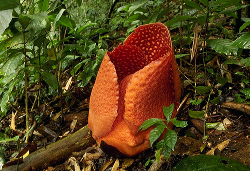
© Karl Lehmann
Bloom
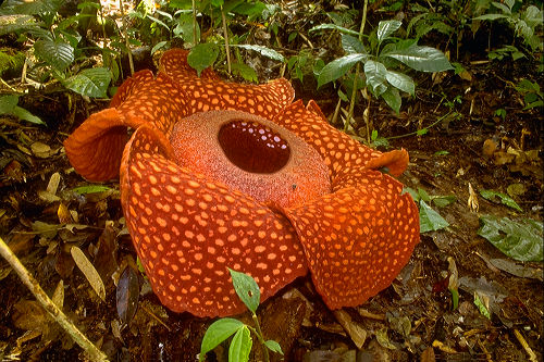
© Karl Lehmann
Look at the size
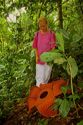
© Karl Lehmann
Photo courtesy of Lost World Arts
----------------------------------------------------------------------------------------------------
Voronya Cave, Krubera, Georgia : Deepest Cave on the Earth
The Voronya Cave (aka Krubera-Voronia Cave) is the deepest known cave in the world. It is located in the Arabika Massif, West Caucasus, Abkhazia (a region of Georgia in the former Soviet Union). The height difference in the cave is 2,140 (± 9) meters.

See the multimedia content from National Geographic
HERE

----------------------------------------------------------------------------------------------------
Roe River, Montana : Shortest river on the Earth
The Roe River, which runs between the Missouri River and Giant Springs near Great Falls, Montana, is the shortest river in the world. Officially it is only 201 feet (61 meters) long. Lewis and Clark were the first white men to see Giant Springs and Roe River and it has been preserved today by the state of Montana for us to see and enjoy.
Oregon's D River also has a claim as the shortest river in the world. However in practice the length of both rivers can vary substantially, and to date the Roe River remains the shortest river officially.

(a special thanks to frank for locating this )
----------------------------------------------------------------------------------------------------
Vredefort Crater, South Africa : Largest impact crater on the Earth
Vredefort crater is the largest known impact crater on Earth. Located in the Free State Province of South Africa, the town of Vredefort is situated in the crater. The site is also referred to as Vredefort dome or Vredefort impact site. In 2005, the Vredefort Dome was added to the list of UNESCO World Heritage Sites for its scenic and scientific interest. Dating back 2,023 million years, it is the oldest astrobleme found on earth so far. With a radius of 190km, it is also the largest and the most deeply eroded. Vredefort Dome bears witness to the world’s greatest known single energy release event, which caused devastating global change, including, according to some scientists, major evolutionary changes. It provides critical evidence of the earth’s geological history and is crucial to our understanding of the evolution of the planet. Despite their importance to the planet’s history, geological activity on the earth’s surface has led to the disappearance of evidence from most impact sites and Vredefort is the only example on earth to provide a full geological profile of an astrobleme below the crater floor.

----------------------------------------------------------------------------------------------------
ScoresbySund Fjord, Greenland : Longest & Deepest Fjord on the Earth
Stretching for 350 km (217 miles) this fjord is the longest on the planet earth. It is located in East Greenland , relatively close to Iceland. This is also the deepest fjord at 1500 m deep
Fjord is a narrow inlet of the sea between cliffs or steep slopes. It is typically applied to a narrow inlet in a glacially over deepened valley, usually narrow and steep-sided, extending below sea level and filled with salt water.A fjord is formed when a glacier retreats, after carving its typical U-shaped valley, and the sea fills the resulting valley floor. This forms a narrow, steep sided inlet (sometimes as deep as 1300 m) connected to the sea.

For high resolution image overlay click HERE
----------------------------------------------------------------------------------------------------
Isaouane-n-Tifernine, Algeria : Highest Sand Dunes on the Earth
The world's highest measured sand dunes are those in the Saharan sand sea of Isaouane-n-Tifernine in east-central Algeria. They have a wavelength of 5 km (3 miles) and attain a height of 465 m (1,526 ft).
The nearest oasis is 100 kilometers (62 miles) away. The structures within the dune field are highlighted by the evening Sun, giving a better perspective on their height and morphology. To the north of the photograph the dunes most frequently form in long crescents or "barchans" with a steep, convex face toward the prevailing winds from the west or southwest. To the south of the dune field star dunes predominate, indicating that there is no consistent wind direction there.
This photograph vividly displays the differences between these two major landforms.

The Tifernine Dunes were named after the intermittently-flowing, south-to-north Tifernine watercourse along the southwestern edge of the dunes. The dark, weathered sandstone rocks that border the Tifernine Dunes to the east and southwest have deep, narrow ravines that comprise a well-entrenched drainage pattern through the higher elevations of the surrounding plateau. This erosion process began millions of years ago when the climate was much wetter. This region now receives less than 1 inch (2.5 centimeters) of rainfall annually.
This distinctive geographical feature provides Space Shuttle astronauts with a reference point in the much larger Sahara Desert
----------------------------------------------------------------------------------------------------
Bishop Rock, Isles of Scilly : Smallest Island on the Earth
Bishop Rock is a small rock at the westernmost tip of the Isles of Scilly, known for its lighthouse, and listed in the Guinness Book of Records as the smallest island in the world.
Containing room for nothing more than the uninhabited 45 metre tall lighthouse, the rock acts as the barrier between the British Isles and the Atlantic Ocean. The original lighthouse was begun in 1847, but was washed away before it could be completed. The present building was completed in 1858.

Image © Copyright Richard Knights and available from Geograph British Isles Geograph British
Isles under a Creative Commons license.
----------------------------------------------------------------------------------------------------
Lake Manitou : Largest lake within a freshwater island in the world
Lake Manitou holds the Guinness World Records as "the largest lake within a freshwater island in the world." The lake about 104 km² is located in the Manitoulin Island , which is the is the world's largest freshwater lake island.

With an area of 2,766 km² (1,068 square miles), it is the 174th largest island in the world, and Canada's 31st largest island. Part of Ontario, Canada, the island separates the larger part of Lake Huron to its south and west from Georgian Bay to its east. Manitoulin Island itself has 108 freshwater lakes, some of which have their own islands; in turn a few of these "islands within islands" have their own ponds. spawning grounds for Atlantic Salmon and trout.
----------------------------------------------------------------------------------------------------
Red Sea : Warmest & Saltiest sea on the Earth
The warmest sea in the world is the Red Sea, where temperatures range from 68 degrees to 87.8 degrees F depending upon which part you measure.
Red sea is also the saltiest sea in the world with 41 parts of salt per 1,000 parts of water.
----------------------------------------------------------------------------------------------------
Indonesia : Biggest Archipelago on the Earth
Indonesia is the largest archipelago in the world. It consists of five major islands and about 30 smaller groups. The figure for the total number of islands is 17,508 according to the Indonesian Naval Hydro-Oceanographic office. The archipelago is on a crossroads between two oceans, the Pacific and the Indian ocean, and bridges two continents, Asia and Australia. This strategic position has always influenced the cultural, social, political and economic life of the country.

Indonesia has the most number of volcanoes than any other country on the earth
There are five main islands : Sumatra, which is about 473,606 sq. km. in size; the most fertile and densely populated islands, Java/Madura, 132,107 sq. km; Kalimantan, which comprises two-thirds of the island of Borneo and measures 539,460 sq. km; Sulawesi, 189,216 sq. km; and Irian Jaya, 421,981 sq. km, which is part of the world's second largest island, New Guinea. Indonesia's other islands are smaller in size.
The archipelago is divided into three groups. The islands of Java, Sumatra and Kalimantan, and the small islands in-between, lie on the Sunda Shelf which begin on the coasts of Malaysia and Indo China, where the sea depth does not exceed 700 feet. Irian Jaya which is part of the island of New Guinea, and the Aru Islands lie on the Sahul Shelf, which stretches northwards from the Australian coast. Here the sea depth is similar to that of the Sunda Shelf.
----------------------------------------------------------------------------------------------------
Atlantic Ocean : Saltiest Ocean on the Earth
On the average, the saltiest ocean is thought to be the northern subtropical portions of the Atlantic Ocean, with and average of about 37.5 parts per thousand salinity.
----------------------------------------------------------------------------------------------------
Arctic Ocean : Smallest & least Saltiest Ocean On the Earth
This is due to the melting of ice and rain !!, the average salinity is 30 - 33 parts per thousand salinity.
----------------------------------------------------------------------------------------------------
Mera Peak, Nepal : Greatest Vertical Drop on the Earth
Mera Peak, Nepal, 6604m is the worlds tallest vertical drop.
Glenn Singleman and Heather Swan made a wing suit / base jump from a launch site at 6604m over the East Face of Meru Peak.
Mera Peak lies within the relatively unhabited Hinku and Hongu valleys south of Mt Everest. At 6476m, it is the highest non-expedition peak in Nepal & Greatest Vertical Drop on the earth. The walk towards the summit is very long but never really steep; the last 15 to 30 minutes just before the summit are steep.

© Robert Sulej Image courtesy of www.peakware.com
----------------------------------------------------------------------------------------------------
Lake Titicaca : Highest Navigable Lake on the Earth
Lake Titicaca (Spanish: Lago Titicaca), at 3821 m (12,536 feet) above sea level, is the highest commercially navigable lake in the world. It is also South America's largest freshwater lake, with a surface area of approximately 8300 square kilometers.
Located in the Altiplano high in the Andes on the border of Peru and Bolivia, Titicaca has an average depth of between 140 and 180 m, and a maximum depth of 280 m. The western part of the lake belongs to the Puno Region of Peru, and the eastern side is located in the Bolivian La Paz Department.

----------------------------------------------------------------------------------------------------
Dead Sea, Israel & Jordan : Lowest Elevation on the Earth
The very bottom of the dead sea , in the deepest part, is over 2300 ft below sea level, is the lowest elevation on the Earth.It is the lowest body of water on earth, the lowest point on earth,


and the world's richest source of natural salts.
----------------------------------------------------------------------------------------------------
Challenge Deep , Mariana's Trench : Deepest point on the Earth
Challenger Deep got its name from the British survey ship Challenger II, which pinpointed the deep water off the Marianas Islands in 1951. Then in 1960, the US Navy sent the Trieste (a submersible - a mini-submarine designed to go really deep) down into the depths of the Marianas trench to see just how far they would go. They touched bottom at 35,813 ft/10,915m. That means, while they were parked on the bottom in the bathyscaphe, there were almost seven miles/11km of water over their heads!
If you cut Mount Everest off at sea level and put it on the ocean bottom in the Challenger Deep, there would still be over a mile of water over the top of it!
The deepest measurement of the Challenger Deep currently available was taken by the Japanese and was found to be 35,838 feet.
A plaque to commemorate the world record for the deepest dive to the bottom of the Mariana Trench in 1995
----------------------------------------------------------------------------------------------------
Mt. Everest, Nepal : Highest Elevation on the Earth
The mountain is approximately 8,844 m (29,015 feet) high, although there is some variation in the measurements. The mountain K2 comes in a close second at 28,251 feet high. The reason Mount Everest does not appear to be 29,017 feet tall is because many photos are taken at Everest Base Camp, which is at 17,585 Feet, above Sea Level, which means that the summit of Everest is only about 11,432 feet higher. On May 22, 2005, the People's Republic of China's Everest Expedition Team ascended to the top of the mountain. After several months' complicated measurement and calculation, on October 9, 2005, the PRC's State Bureau of Surveying and Mapping officially announced the height of Everest is 8844.43 m (29,017.07 ft). This new height is based on the actual highest point of rock and not on the snow and ice that sits on top of that rock on the summit. They claimed it was the most accurate measurement to date.
Edmund Hillary and Tenzing Norgay were the first men to ever reach the summit of Mt. Everest . Since then approximately 1,200 men and women have made the daring journey to the top of Everest.

----------------------------------------------------------------------------------------------------
El Azizia , Libya : Hottest place on the Earth
On September 13, 1922 the meteorological station in El Azizia recorded a blistering 136° F/ 57.8° C, Note that this was the temperature on the thermometer in an enclosed shelter 5 mts above ground , some claim that the actual temperature on the ground could have reached 150° F/ 66° C !! and else where meters away from the Met dept the temperature could have been still higher !!

Death Valley, California comes in a close second, On July 10, 1913 this place recorded 134° F/ 56.6°C .
These records are based on the air temperature measurements done by weather stations scattered across the earth. But the actual temperature on the surface of the earth at that point of time could have been much higher. A NASA satellite recorded surface temperatures in the Lut desert of Iran as high as 71 °C (159 °F)[2], the hottest temperature ever recorded on the surface of the Earth.

Image Courtesy : www.spiegel.de
----------------------------------------------------------------------------------------------------
Vostok station, Antarctica : Coldest place on the Earth

Vostok Station is a Russian research station located near the Geomagnetic South Pole (see South Pole), at the center of the East Antarctic Ice Sheet. The station is 3488 m above sea level. It is the most isolated of all of the established research stations on the Antarctic continent.
It is the place on Earth at which the lowest temperature has been reliably measured (though since the temperature decreases with height, it is virtually certain that lower temperatures occurred higher up towards the summit of the ice sheet). During the long winter, temperatures average about −65 °C; in the brief summer, about −30 °C. The place is known as the Southern Pole of Cold. The coldest temperature ever recorded on Earth, −89.2 °C, was measured here on 21 July 1983. Although still unofficial, an even colder temperature, −91 °C, was reported during the winter of 1997.
In 1996, Russian and British scientists discovered Lake Vostok, the largest known subglacial lake in the world underneath Vostok Station. Lake Vostok lies some 4,000 meters (13,000 feet) below the surface of the central Antarctic ice sheet and covers an area of 14,000 square kilometers (5,400 square miles).
It was built in 1957 (IGY) and named for one of Bellinghausen's two ships, Vostok (East). Although this is a Russian research station, scientists from all over the world conduct research here. One of the primary projects at this site, a coordinated Russian, French and American effort, is drilling an ice core through the 3,700 m thick ice sheet. This ice core contains climate records for almost half a million years before present.
----------------------------------------------------------------------------------------------------
Cherrapunji, India : Wettest place on the Earth

The city of Cherrapunji at 1290 mts above sea level is the wettest place on the Earth.
In Cherrapunji it rains so much for two reasons:
- Elevation: because of the elevation of Cherrapunji, air that blows over the plains below is cooled as it rises to the higher elevation. This cooling of the air causes the moisture trapped in the air to condense, forming clouds, which then release rain.
- Monsoons: the prevailing winds in that part of the world are very heavily laden with moisture. The constant supply of moist air for six months straight results in almost continual rainfall

----------------------------------------------------------------------------------------------------
Atacama Desert, Chile : Driest place on the Earth

The Atacama desert receives on an average less than .004 in / .01 cm of rainfall per year , some parts of this desert have not recieved rainfall for over 400 years !!
The Atacama desert is nestled along the coast of Chile, South America - right next to the Pacific Ocean - the biggest body of water in the world. Much of the desert extends up into the Andes mountains and is very high in elevation. Unlike more familiar deserts, like the Sahara desert in Africa and the Mojave in California, the Atacama is actually a pretty cold place, with average daily temperatures ranging between 0°C and 25°C. The annual rainfall (or lack of it) defines a desert, but that doesn't mean that it never rains in Atacama. Every so often a warming effect over the Pacific Ocean around the equator changes the weather the world over and even places like the driest desert in the world can become doused with drenching storms. Even though Atacama gets almost no rainfall, there is water in this arid place in the form of Salt Lakes, Snow, Underground Water Fog and Dew.
Some contend that Antarctica is the driest place on earth , technically it is a dessert. It receives less than two inches of precipitation a year, about the same amount of precipitation as the Sahara Desert.
One interior region of the Antarctic is known as The Dry Valleys. These valleys have not seen rainfall in over two million years!!. With the exception of one valley, whose lakes are briefly filled with water by inland flowing rivers during the summer, the Dry Valleys contain no moisture (water, ice, or snow). The reason why the Dry Valleys exist are the 100 mph Katabatic down winds which evaporate all moisture.
I leave it to you to decide which one you consider as the driest place on the earth
----------------------------------------------------------------------------------------------------
Mill Ends Park, Portland, Oregan : Smallest Park on the Earth
Mill Ends Park in Portland, Oregon is the smallest park in the world, according to the Guinness Book of Records. The "park" is a 2 foot (610 mm) wide circle which in 1948 was intended to be the site for a light pole. When this failed to appear, Dick Fagan, a journalist for the Oregon Journal, planted flowers in the hole and named it after his column in the paper, "Mill Ends". Fagan told the story of the park's origin as follows: He looked out his office window and spotted a leprechaun digging in the hole. He ran down and grabbed the leprechaun, which meant that he had earned a wish. Fagan said he wished for a park of his own; but since he had not specified the size of the park in his wish, the leprechaun gave him the hole. Over the next two decades, Fagan often featured the park and its head leprechaun, named Patrick O'Toole, in his whimsical column.
Fagan died of cancer in 1969, but the park lived on, cared for by others. It became an official city park in 1976. Mill Ends Park is located at SW Naito Parkway and SW Taylor in downtown Portland.
The park's area is 452 in² (0.29 m²). The small circle has featured many unusual items through the decades, including a swimming pool for butterflies (complete with diving board) and a miniature ferris wheel (which was delivered by a regular-sized crane).

Courtesy : Wikipedia
----------------------------------------------------------------------------------------------------
Angel Falls, Venezuela : Tallest water fall on the Earth
Angel Falls or Salto Ángel is the world's highest free-falling waterfall at 979 metres (3,230 feet) with an uninterrupted drop of 807 metres (2,647 feet). It is located on an unnamed tributary of the Rio Caroni, in the Canaima National Park, Venezuela.
Angel Falls is the tallest waterfall in the world, as well as the tallest single drop in the world. The falls consist of a 2648 foot plunge, where the water comes out of the face of Auyan Tepui, then it cascades down steep talus before dropping over another 100 foot cascade. No one seems to know what the stream the falls occur on is called. For the longest time, there have been references to Angel Falls being known in Pemón (the local language) as Churún Merú, and the falls subsequently being on Rio Churún. However, the real Pemón name of the falls is Kerepakupai Merú, which means "fall from the deepest place". To further clear this issue, Churún Merú is a totally different waterfall of about half the height of Angel Falls, located further up the large canyon bysecting Auyan Tepui. The top of the Tepui from which the falls drop is heavily fractured and jointed sandstone. The waters above the falls drop into a series of cracks, crevices, and gorges and burst out of the cliff face about 50 feet below the brink. The waterfall segments in periods of highest water. We've seen photos that show the falls split into 3 major portions,
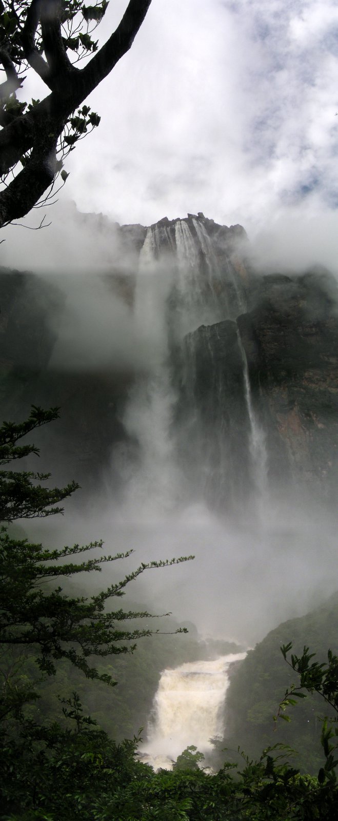
creating a veil of water on the order of 600' in width. Pilot Jimmy Angel is widely credited for discovering the falls in 1937, but the true discoverer was one Ernesto de Santa Cruz, who found the falls in 1910. The falls were subsequently named for Jimmy Angel, since he was the first westerner to view the falls.
----------------------------------------------------------------------------------------------------
Mauna Loa, Hawii : Biggest Mountain on the Earth
If you thought Mt. Everest , You are wrong 
Everest is the highest elevation on land, but it is only a single peak in an entire mountain range. Mauna Loa is a single mountain on the island of Hawaii. The island of Hawaii is actually an island made up of five volcanoes which "blend" together because of their closeness to each other, making a single island.
Only about 13,448 ft/4100m of Mauna Loa are above sea level, so it may not seem like a very tall mountain. But, when you start measuring Mauna Loa from its true base on the bottom of the ocean, in the Hawaiian Trough, the total height exceeds that of Everest by over 3/4 of a mile. The total height is around 33,132 ft / 10,099 mts !!.
Mauna Loa is Hawaiian for "Long Mountain", probably because of its long, gently sloping shape.
----------------------------------------------------------------------------------------------------
Mauna Kea, Hawii : Tallest Mountain on the Earth
If you want to get really technical, Mauna Kea, a neighbor of Mauna Loa on the same island of Hawaii, is actually the tallest mountain in the world at 33,472 ft / 10, 206 mts. Mauna Kea is about 350 ft/107m taller than Mauna Loa, but its mass doesn't compare to that of Mauna Loa. Mauna Loa takes up a lot of space because its mass is 9,700 cubic miles/40,000 cu km of mountain!

----------------------------------------------------------------------------------------------------
Wilkes land, Antarctica : Thickest Ice Sheet on the Earth
The thickest part of Ice ever measured was at 320 Kms inland from the shores of the Wilkes Land in Antarctica. The east Antarctic ice sheet is the single largest piece of ice on the entire earth and at some regions it is almost 3 miles / 4.8 kms thick, thats as high as the Alps.
It is interesting to note that Antarctica accounts for 90% of the entire planets Ice !!

----------------------------------------------------------------------------------------------------
Lake Baikal, Russia : Deepest Lake on the Earth
Russia's Lake Baikal, located north of the Mongolian border, is the world's deepest with a maximum depth of just over one mile (5371 feet / 1637 meters). Lake Baikal is so deep that it holds about one-fifth of the world's non-frozen fresh water supply.

----------------------------------------------------------------------------------------------------
Titan Arum, Indonesia & Talipot palm : Largest Inflorescence on the Earth
Basically there are two types of inflorescence, the unbranched and the branched inflorescence
The Titan arum or Amorphophallus titanum is a flowering plant with the largest unbranched inflorescence in the world. It was originally discovered by an Italian botanist, Odoardo Beccari, in Sumatra in 1878. Though found in many botanic gardens around the world it is still only indigenous to the tropical forests of Sumatra. Due to its fragrance, which is reminiscent of the smell of a decomposing mammal, the titan arum is also known as a carrion flower, the "Corpse flower", or "Corpse plant" (in Indonesian, "bunga bangkai" – bunga means flower, while bangkai means corpse or cadaver; for the same reason.
The titan arum's inflorescence can reach over 3 metres (almost 10 ft.) in height. Like the related cuckoo pint and calla lily, it consists of a fragrant spadix of flowers wrapped by a spathe, which looks like the flower's single petal. In the case of the Titan Arum, the spathe is green on the outside and dark burgundy red on the inside, and deeply furrowed. The spadix is hollow, pale yellow and resembles a large loaf of French bread. The upper, visible portion of the spadix is covered in pollen, while its lower extremity is spangled with bright red-orange carpels. The "fragrance" of the inflorescence resembles rotting meat, attracting carrion-eating beetles and Flesh Flies (family Sarcophagidae) that pollinate it. However Amorphophallus titanum exudes this foul odor for only 8 to 12 hours while blooming. The flower's deep red color and texture contribute to the illusion that the spathe is a piece of meat. During bloom, the tip of the spadix is approximately human body temperature, which helps the perfume volatilize, this heat is also believed to assist in the illusion that attracts carcass-eating insects.
 Credits : US Botanic Garden
Both male and female flowers grow in the same inflorescence. The female flowers open first, then a day or two following, the male flowers open. This prevents the flower from self-pollinating.
After the flower dies back, a single leaf, which reaches the size of a small tree, grows from the underground corm. The leaf grows on a semi-green stalk that branches into three sections at the top, each containing many leaflets. The leaf structure can reach up to 6 m (20 ft) tall and 5 m (16 ft) across. Each year, the old leaf dies and a new one grows in its place. When the corm has stored enough energy, it becomes dormant for about 4 months. Then, the process repeats.
The Talipot palm bears the largest brancehd inflorescence, 6-8 m long, consisting of one to several million small flowers borne on a branched stalk that forms at the top of the trunk. The Talipot palm is monocarpic, flowering only once, when it is 30 to 80 years old. It takes about a year for the fruit to mature, producing thousands of round yellow-green fruit 3-4 cm diameter, according to calculations they produce about 12 million flowers, which contain more than 500 kg of seeds !!
Once it bears fruits, the plant dies. It gradually uses up all the nutrient reserves accumulated in the trunk over the decades.

source


